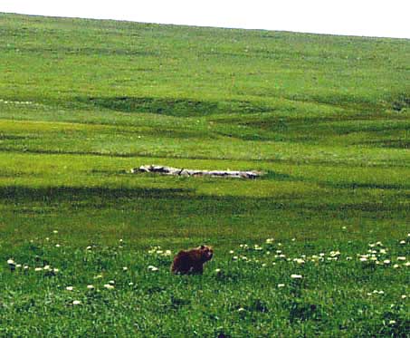
When I landed and walked
to the old boat there was
a bear guarding it. The
remains of the boat
are in background
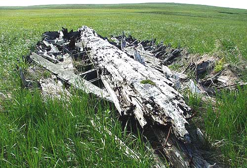
A view looking down the keel. Most of the planking has rotted away. The
remains here
are about 50 feet long and
18 feet wide. Has it been
in this place 264 years
or 49 years?
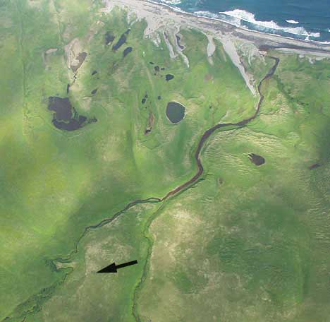
An aerial point of view
from 5 thousand feet.
The arrow points out the
location of the boat
which is about one kilometer
from the ocean.
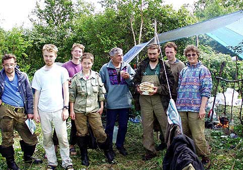 The geologist who were
studying tsunamis.
(Click on any Image to see a higher resolution version)
The Pacific coast, ten miles
east of here, is such a wild place it can take my breath away. I have
never seen anyone there, in the six years we have been here, until a month
and a half ago. That day was clear and calm everywhere but along the shore
and for some perverse reason I was flying there in the fog. I had gone
down to the southern cape of Lopatka (see
July 21st 1999), which was half in and half out of the fog rolling
in from the east coast. Because it is so flat there, I experimented flying
into the fog because, first I wanted to visit an object I had spotted
the last summer and second, the fog was quite thin giving me about 400
feet visibility ahead. What I was looking for was a very old wooden boat
on a small rise of ground about one kilometer inland. As you can see from
the photos taken later, it has rotted almost completely into the tundra.
There was enough visibility to safely navigate as long as I did not lose
track of where I was, so not being surprised by a sudden rise in the ground
or other obstacle in front of me. After some looking I found the old boat.
There was no place to land near by so I looked it over again from a few
feet above it, then decided to continue north, up the coast to the Gavrilovskaya
River where I knew if I turned upstream I could fly back into sunshine.
On my way south, I had seen how the fog lay. The thought did cross my
mind that it was a bit silly after six weeks of bad weather that I felt
compelled to fly in the fog.
Following the top of the bluff above the breakers for 25 kilometers, I
knew I was getting close to the mouth of the river when the bluff almost
petered out. Suddenly, a few feet below me, I saw three people digging
in the near vertical face of a sand dune where a small stream had cut
through it to the sea. There are always many thing to see along this coast,
but this was a surprise to me. I had not seen this species here before.
A kilometer ahead I came to the river mouth so decided to land and walk
back to see who these people were and what they were doing. They had looked
to be Russian, in that none of them wore brightly colored, Patagootchi
styled windbreakers, and one was a woman which suggested to me they probably
were not poachers. Along this stormy shore it would seem most likely that
they could be survivors from a shipwreck but there had been no signs of
distress when I flew over them.
When I got to the creek, I was greeted with smiles and some element of
surprise given that I showed up out of the mist. It turned out that the
woman was Joanne Bourgeois from the Department Earth and Sciences of the
University of Washington in Seattle. The other two were from the Institute
of Volcanic Geology and Geochemistry in Petropavlovsk. What they were
digging were pits for looking at freshly exposed soil. From these they
could see the history of various geologic events like tsunamis using ash
layers of carefully dated volcanic eruptions as guidelines. Joanne was
on sabbatical leave and with several other Russians had put the expedition
together. They had come by helicopter and at the time were split into
two groups. One group was hiking to Kambalnoye Volcano.
I told them about the old boat I had found and they agreed that it was
peculiar. I said I would return to their camp, which by then would be
up the coast at Vestnik Bay. I would bring my computer with digital photos
installed so they could judge as to whether it was a tsunami that had
deposited the boat so far inland.(Tsunami = a long high sea wave caused
by underwater earthquakes or other disturbances (Oxford Canadian Dictionary))
There were two possible dates that it could have happened, the first was
1737 (not too likely, but very interesting if it was) and the second was
1952.
By the time I got my photos, the eight geologist had hiked 50 kilometers
north, a very strenuous trip as there is no cut trails through the alders,
birch and pine, only bear trails that don't lend themselves well to traveling
with heavy packs. The way they seemed to be so at home in the wilderness
it was not difficult to see these were bush people. They planned to be
in the field for most of the summer and their budget did not allow for
more than a couple helicopter support flights. One of these had brought
three more specialists, two from Moscow and one from Spain. There were
now 11 in the party and all but two were Russian.
The expedition leader and Russia's top tsunami expert, was Tatiana Pinegina
from Petropavlovsk. Looking at my digital photos, she thought that it
was definitely a tsunami that had put the boat so far inland and maybe
even the 1737 one. Natasha, from Moscow, specialized in radiocarbon dating
and wondered if it was possible for me to get her some of the youngest
looking wood. The radiocarbon date measures from when that part of the
tree actually grew, so if second hand wood was used for building the boat
and then also the tree which it was hewn from was very old to begin with,
the results the dating could be misleading. I remembered one plank had
struck me as surprisingly non deteriorated, possibly used for repairs
long after the boat had been built, so promised to get a bit of it for
her to date. If it was pre 1737 it would have been sailing here before
Vitus Bering struck out from Petropavlovsk and discovered Alaska in 1741.
Another very interesting woman, who said she has been reading our web
page ever since it started, was Vera Ponomareva. She divides her time
between Moscow and PK and is Kamchatka's leading volcanic geology expert.
It was her who unraveled the history of how Kambalnoye Lake was formed.
It is not a caldera (collapsed volcano) as I had previously been informed
(I hope to edit our book manuscript to reflect this better information).
The lake formed behind a dam created by a landslide 6900 years ago. The
slide came from the top of Kambalnoye Volcano with such force that it
slid over another mountain ridge, traveling a total of 12 kilometers to
get there. Given my ability to view the land from several thousand feet
in the air, I can now see very clearly the whole story once she told me
what really happened.
Having collected the piece of wood I returned to their last camp far to
the north, 1 1/2 months after I first met them in the fog, but they had
packed up and left the day before I got there. I have been in touch with
Joanne and Vera by e-mail and Maureen visited with them while she was
in the city. It is people like this that greatly add to our understanding
of this dynamic peninsula.
- Charlie